Showing posts with label Hiking. Show all posts

Sunday, June 23, 2013

Lake 22 - Perfect Reflection


Lake 22, located on Mt. Pilchuck east of Everett, is a truly fantastic day hike. The trail head has a small parking lot. We reached around 12 and the parking was full. The cars were parked even on the main road. We waited for some time and got a parking. The trail head also has rest rooms just in case you wanna start fresh (as there are no restroom, water source on the trail). This hike is around 5 .5 miles round trip. As the WTA site says it good for kids, so i brought my 3.5 year son too. 

The trail starts flat and seems good. The trail winds gradually uphill most of the way. There's a nice variety of landscapes too in the shady pine forests. The trail most of the time follows the course of a river (you will come across many beautiful waterfalls, and even a beaver dam when we were there). After a mile or so you will come across the rocky part of the trip which spans for around quarter mile (my son had a hard time crossing it). 

Once you cross the rocky part, you will cross a little wooden bridge and everything opens up to the lake. It's BEAUTIFUL and the water is surprisingly warm. An ultimate Gods creation - crystal clear Lake 22 surrounded by mountains. The water is so clear and still, you will have the perfect reflection. Nice photographic place with the backdrop of mountains having multiple waterfalls (6). Though there was lot of snow on the board walk, but you can still walk and reach out to the far end points of the boardwalk towards the foothill. 

It took us about 3 hours to hike up to the lake and about half the time to get back down. We took our time and stopped a lot for pictures. So, I would think it may take about an hour less for faster hikers to get to the top. 

Definitely a place I would love to go back to again.

Notes: 

- Bugs are there so Bugspray is recommended
- No water source in the trail so carry water.
- Will not recommend for small kids, they can be at backpack.
- Carry a Forest Pass (you can buy the pass from the Verlot Public Service Center or any REI)
- The final 100 yards was all snow even in July so poles will be nice to carry along.

Driving Directions: 

From Granite Falls follow the Mountain Loop Highway east for 11 miles to the Verlot Public Service Center, Proceed 2 more miles to the trailhead, on your right (elev. 1050ft)


Saturday, June 15, 2013

Bridal Veil Falls, WA

Nice hike to a amazing falls.

We started around 12 PM, the parking lot was all full. As per WTA this is a kids friendly hike, so i bought my little one who is three and half too. The hike starts in shade and climbs very fast to around 2000+ft. I heard there were around 23 switchbacks, so was sort of prepared for them. 


As the trail starts there are a lot of stairs, uneven ground but not too bad that it cant be hiked. 


The hike is 5.2 miles round trip, which was bit long for my son. The hike has something for everyone. You can go to the falls and the lake. After around 2 miles you will see a directions board, you will have to decide if you want to see the Lake Serene or the Falls. We went only to the falls, but like I said its really worth it. If you chose one or the other (I can't say anything about the Lake) but go to the falls.The falls are pretty, the views across the valley are pretty, and the stairs will put you just below the falls which is awesome.

As such there is not many places to sit and relax or have food near the falls. But we somehow crossed the water stream to the other side to the dry rock and had our lunch enjoying the valley view. If you have trekking poles they'll come in handy but they're totally not necessary. This hike requires a NW Forest Pass.


Driving Directions:
To get to the trailhead, travel east on Highway 2 (paved) from Monroe, WA. At milepost 35.2, about 21 miles east of Monroe, turn right onto Mount Index Road (Forest Road 6020 - gravel). Travel 0.3 mile on Forest Road 6020 and branch right onto Forest Road 6020-109 (gravel). The trailhead parking is just ahead. The junction is signed. Forest roads 6020 and 6020-109 are both passable to any passenger vehicle. A Northwest Forest Pass is required to park at the trailhead. There are two outhouses in the parking area, elevation: 600 feet.


Wednesday, December 19, 2012

Snowlake Trail, Northbend


Snow lake was a beautiful 2.5 mile hike,we went for a nice hike to snow lake today. Its about 40 miles east on i90. take exit 53 and hang a right and another right. then drive down a little bit and you'll see a small group of service stations, ski lodges, etc. you should be able to find the visitor center on your right. you have to go there no matter what, b/c you need to buy a parking pass for $5. from there they can tell you exactly how to get to the snow creek trail.

we started the hike at 11:10am and it was already crowded.The parking lot was jam packed with around 100+ cars. Lots of passing and being passed, but then also the sign of a nice trail.  I saw lots of families with kids of all ages and dogs too, so it seems pretty friendly for families.

We spent a wonderful afternoon at this place, beautiful sunny mid 70 degree weather and a wonderful hike up to snow lake. The trail is well maintained but it's still relatively rocky and uneven so hiking shoes are helpful. sunblock/hat/glasses are helpful especially on a sunny day because this trail has lots of unshaded portions. near the lake the temperature is noticeably cooler, so i was glad we wore layers and brought track jackets.

the trail winds its way up several switchbacks of the crest of a ridge and then down into the snow lake basin. It took around 2.5 hours to reach the lake. We did saw iceberg on the other side of the shore, left over from the previous winter. The lake is beautiful and once you get down into the basin there are lots of little trails to go exploring on. The lake has a big shoreline so every one can get their own space. If somebody is intrested in bird watching this is a very nice place too. We had our lunch there. Be carefull of eating the food in open as birds might fly over and snatch the food as it did for us :)

Saturday, August 25, 2012

Mailbox Peak Trail - BE PREPARED

As all reviews say, Mailbox Peak is really no joke. It is a 2.5 mile Death March for the unprepared, and an ass kicking workout for the prepared. Don't let the mere 2.5 miles fool you.
You walk up the forest service road about 1/2 mile until you get to the official entrance to Mailbox Peak trail head next to the notice board. Be very carefull to take the entry immediately from the notice board, as once i(and many others) went straight and wondered in the forest for 1.5 hrs trying to find the trail head.  The first 1/4 mile of trail you are meandering in a forested area with a few nice cold creeks running through. You will find these useful to soak your tired feet when you get back down. This little jaunt doesn't last long as the trail goes into full business mode with the quickness. No transition, no feeling out process, just you looking at this straight up, root stepped, steep as hell thing saying "DAMN!"

Welcome to Mailbox Peak.

This part of the trail you are under the tree canopy and more often than not you will run into some serious mud, roots, logs and assorted things you have to climb over or around. The switchbacks are more like s-turns as they seem to not want to give you much of a break and just push you up up up the hill. If anyone says "it gets easier" or "you're almost there"...they are lying :)
After what seems to be an eternity, eventually you will break out of the tree line and will finally have some nice scenery with lots of flowers and big views, but the most apparent view will be the huge boulder field in front of you. If you are not up to the scramble challenge, just follow the left edge of it, the trail will be apparent. Plenty of false summits, but I do think once you are out of the tree canopy, the going gets much easier and even if it is muddy, it seems there is more rock mixed in for better grip. Eventually you will reach the mailbox.

Sunday, August 19, 2012

Twin Falls, Northbend

From where I live in Tukwilla, it took less than 45min to travel from the 'hood to the trailhead...pretty quick!  Twin Falls by itself is nothing to write home about.  This was a fun, easy hike with family with a nice water feature! It's a quick, cute hike and there are nice views of the river and waterfalls. There's even a "secret" path where you can climb all the way down to the banks, where you can make your way to the boulder in the middle of the river. It's a great place to break, sunbathe, snack, enjoy the rush of the water around you. 


The natural beauty in the Cascades is lush, wet and green: it is impressive to see fallen trees on the forest floor, almost completely grown over by moss and new plants.  There are some old growth trees which tower above everything else and their trunks provide excellent perspective on what it takes to hold up a huge-ass tree for hundreds of years.  In the forest, moss and vines are everywhere and lend a creepy quality to some of the dark scenery seen beyond the trail. If you go past the falls all the way to the top you just reach a gravel road and a dead tree.Kind of anti-cilmactic.

The trail itself is excellent: I saw people with strollers and a few frail-looking elderly folks moving along with no problem even my son of 2.5yr old didnt have much problem.  The trail is mostly packed dirt and there are a few places with wooden steps.  If you don't get out much, the trail might be tiresome; but if you are at all physically active the trail is very easy. 

It's not a steep hike, but it is uphill on the way back, which is always a little masochistic for me. If you want something with more distance, you can always park away from the traditional parking lot for Twin Falls (exit 34??) and instead east from Rattlesnake Lake on the Iron Horse Trail. Easy hiking warmup and a decent enough view.

I recommend Twin Falls to anybody who lives in Seattle...it is so close, so pretty and so fun to romp around a forest for exercise.

Wednesday, May 30, 2012

Franklin Falls, WA - Lets Hike..


Franklin Falls Trail No. 1036 begins on Denny Creek Road on the west side of Denny Creek, elevation 2,300 feet. Franklin Falls is by no means one of the tallest waterfalls I’ve come across. It sits in a canyon directly in between the east and westbound lanes of I-90 near Snoqualmie Pass. The surreal experience of standing just beneath one of the nation’s most important freeways and staring at a beautiful sight like these falls is certainly something worth the short hike required to get to them (only about 2 mile returntrip). It does, however, for all its benefits have one major downfall. It is fairly popular and you will likely be accompanied by several people while enjoying this scenic sight.

As per the recommendations from several sites, I visited this place in May with my 2.5 year old son. Park at the bridge if there is room otherwise continue a short distance to the Denny Creek/Melakwa Lake trailhead at the end of the road. Though my son very active in hiking but we carried him over as the the path was full of snow. The overall trip was about 3 hours. On the way you can see several ancient trees grace the trail, and spur trails lead to better views of Denny Creek.

I do not recommend for children, because the terrain is steep and there are no guardrails.

Monday, September 12, 2011

Glacier National Park, Montana

I used to always tell people that the most beautiful place that I'd been to was Yellowstone National Park in Wyoming. Well, after a long awaited trip to Glacier National Park in Montana, I've changed my tune. I will still tell people that they must go to Yellowstone before they die but I'll also add Glacier to that list. Without actually seeing it with one's own eyes, it's hard to simply read a description of the majestic peaks and valleys carved out by glaciers during two ice ages and understand the magnitude of the natural beauty there.


Open June through October, the spectacular Going-to-the-Sun Road winds 52 miles through stunning glacial scenery, crossing the Continental Divide at Logan Pass. Hiking trails allow those who venture on them to steal glimpses of the heart of this majestic wilderness and its abundant wildlife, including bears, elk, moose and bighorn sheep. Highline Trail offers opportunities to explore deep into the park during summer.

 There are so many places to stop and get out of your car (or the red bus) to snap a photo, take a walk, or simply be overwhelmed at the spectacle before your eyes. Beautiful views although once you hit the pass, the driver cannot look at anything but the road as it is winding with construction and sheer drop-offs.Sun Point is a short walk to a fantastic view. At Hidden Lake Overlook, a short walk up wooden steps from the Logan Point parking lot leads to a gorgeous view. A bit farther on you reach snow


St. Mary Lake: On our last day in Glacier, we drove the entire Going to the Sun Road, stopping at every sight along the way. Our first stop was St. Mary Lake from the Sunrift Gorge parking lot. The lighting in the early morning produced beautiful reflections of the mountains surrounding St. Mary Lake. I must say that some of our best photographs.


Some of the most beautiful waterfalls you'll ever see can be found on the eastern side of Glacier National Park, just a short walk from Going to the Sun Road.  As you drive east across the park, the first waterfall trail you reach leads to St. Mary Falls. The picturesque trail to St. Mary Falls is very worthwhile, and the falls are beautiful. Instead of returning to the trailhead after reaching St. Mary Falls, I'd recommend going on to Virginia Falls; it has more elevation gain, but it's worth it to see both falls. Be sure to take drinking water.

Wednesday, December 22, 2010

Deception Pass - "Hauntingly Beautiful"


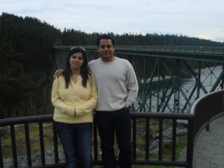
Me & Wifey at Deception Pass Bridge 
Deception Pass is a unique and hauntingly beautiful state park in northwestern Washington, about 45 minutes north of Seattle. Although you can camp and hike here, the real allure is the pass itself, named "Deception Pass" since it is really an island. As soon as you cross over the bridge that looks out over the area, stop your car and hike down onto the rocky precipice that juts out like a delta in the waters. 
From this vantage point you can spend hours watching boats try to traverse the strong waters and exit into the sound. 

There are blueberries, sinds, wildlife and more. We didn't like camping here much; loud jet planes all night, drinking parties, no enforcement of quiet hour. Being there in the day was great: It's beautiful, it's spectacular, it has great beach and trail walking, and there's always the bridge. We hiked up to Goose Rock and had a great view. 

Wednesday, September 30, 2009

Awesome - Yellowstone

Everyone should see Yellowstone at least once in their lifetime. America's first national park was established in 1872. Home to an abundance of wildlife, from grizzly bears and wolves to bison and elk, Yellowstone covers areas of Wyoming, Montana and Idaho. The park is truly incredible and their is something majestic around every corner. From the geyser fields Yellowstone River multiple waterfalls, extraordinary geysers(Old faithful), the majestic scenery and the abundance of wildlife. I have been once at the end of winter and was awesome. Snowmobiling was one of the activities, i would recommend. I would also recommend going when the park is not as busy so that you can truly enjoy the beauty and the peace and quiet. Too many people congest the park and that can be a big disappointment. I will go to Yellowstone again and again. Its a 12hr drive from seattle, so you need atleast a long weekend to visit.

Tuesday, July 7, 2009

Land of Awe: Mt. Rainier, WA

At 14,410 feet, Mount Rainier is the fifth highest mountain in the continental 48 states. Its a beautiful 2Hr drive from Seattle. Mount Rainier National Park is a gorgeous place. Any traveler can enjoy the mountain's grandeur without having to be an experienced mountain climber. The visitor's centers offer amazing views from the comfort of a heated building. On your way to Paradise Inn, be sure to stop by various waterfalls and have pictures. However, be prepared for snow and view-obstructing clouds to move in at any moment. The clouds moved in quickly while leaving the park, making for about 15-minutes worth of white-knuckle driving on the Chinook Scenic Byway. Be sure to check the weather before you go.

Oregon Scenic Views - 101


If you plan to travel through Oregon and have the time to take the scenic route through the state along Highway 101, you won't be disappointed. It takes around 4hrs drive to reach the ocean shore from Seattle. The views and interesting day trips are many and varied. 45 miles north of the border is the Rogue River. 3 miles south of Florence you'll come to a lot of sand dunes and Honeyman Park. It is the second largest state park campground in the state. There are two miles of sand dunes between the park and the ocean.You can take a dune buggy (holds about 20 people) ride through the dunes. You can rent smaller dune buggies, too.   This is a great place for playing in the sand and freshwater lake.

11 miles north of Florence are the Sea Lion Caves. This is a natural cavern where sea lions live. There are about 200 Steller sea lions that make the caves their home. It's also a great spot to get a great picture of Heceta Head lighthouse, considered by many to be the most photographed lighthouse on the west coast.

Wifey!!
Just north of Newport Bay is Yaquina Head lighthouse and state park. There is a day use fee here, too, but it includes alot. There's a lighthouse which you may be lucky enough to tour---it isn't open all the time. Finally, you'll come to Astoria.  A beautiful hilly town with victorian houses and fishing on the Columbia River.

Monday, May 25, 2009

Crater Lake, Oregon

Crater Lake is the deepest lake in the United States, and one of the most beautiful!  The lake was formed after the collapse of an ancient volcano named Mount Mazama. I drove from Salem to Roseburg and took the Mapquest âs directions to Crater Lake. It takes around 6hrs drive from Seattle. It was simply wonderful I loved seeing the points near Crater Lake in the distance, and the beautiful little purple flowers on the side of the road.We started noticing the snow right away, so we pulled over and played in it! When we got to the first lookout, I rounded the corner and nearly lost my breath, it was astounding to say the least.

Finally we were at Rim Village, The Gift shop had some very cute and pretty things, I picked up Christmas Ornaments that were on clearance, a photo box, a envelope of standard size postcards, and a beautiful turquoise necklace. 

Friday, May 22, 2009

Picture Perfect - Hurricane Ridge, WA


We spent one full day in Olympic Nation Park and hit all three elements (Hurricane Ridge-mountain, Hoh Rain Forest-rain forest, Rialto Beach-ocean). Hurricane Ridge was our first stop out of three.

Hurricane Ridge is about an hour and a half drive up the mountains from Port Angeles. I'd consider the drive to be mountain driving, it's slow but very beautiful. The visitor center at the end of the road had plenty of park rangers, a nice gift shop, but was also very crowded. We spent about two hours here wandering the trails, and the views were almost too beautiful to be true. We visited in August and even then the Olympic Mountains were snowcapped.


 I'd definitely return to Hurricane Ridge, and I'd recommend you visit for yourself. In fact, of all the places that we visited in the Olympic National Park , this was probably my favorite.